

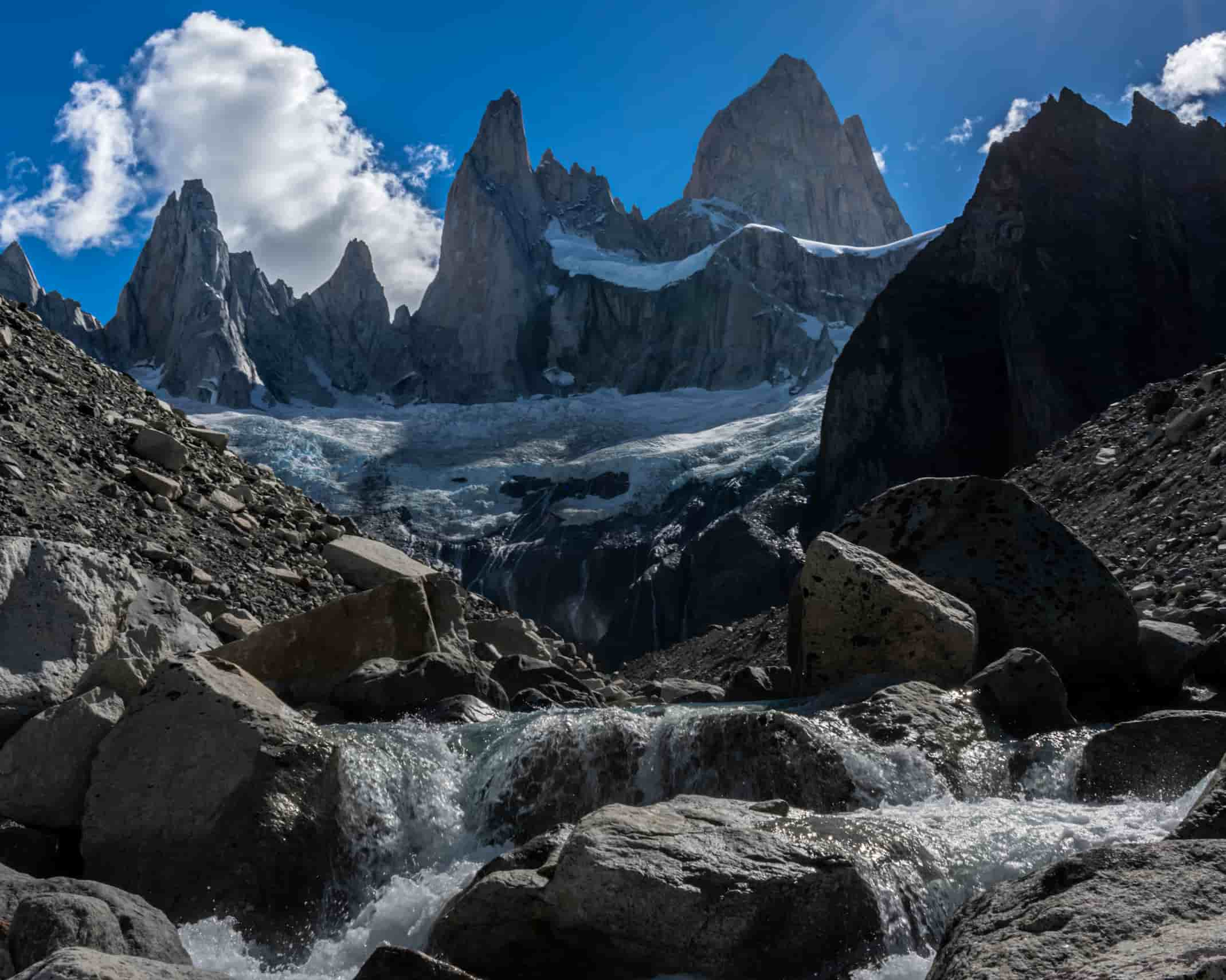
A demanding trek that takes place mainly over large rocks and can be difficult and slow. But the reward upon arrival is spectacular: An incredible view of Fitz Roy, where it literally seems that “it falls on top of you“.
Important: This tour takes place in an area of Los Glaciares National Park that is considered a “Remote Area“, so it is essential to have some mountain experience to do it. The trails are not signposted as in the case of the treks that are part of the backbone network (Laguna de los Tres, Laguna Torre, etc.), nor is there medical assistance nearby or campsites with amenities.
Use the described information only as a reference, and before starting it is recommended to go to the “Cerferino Fonzo” Visitor Center to obtain updated information about the route and the necessary equipment.
Registration of Mountain Use in Remote Areas – Los Glaciares National Park:
Important: The track starts and ends at Poincenot camp (trail to Laguna de los Tres).
Leaving the Poincenot camp and crossing the Rio Blanco bridge (always following the trail to Laguna de los Tres), you climb a small staircase of logs, at the end of this staircase you have to look for the beginning of the trail to Laguna Sucia which is blocked with some logs (you can also see a sign of blocked trail).
Following the path, we go down to the river banks and we must follow the pircas (or monoliths) that will indicate the way. In case you miss the pircas, keep going upstream but try to go as close as possible to the vegetation.
From here on we will be practically jumping from stone to stone (that is why it is important to wear shoes) until we reach a BIG STONE that prevents us from continuing.
At this point we have 2 alternatives:
In any of the 2 cases, the path continues advancing always by the right margin until finding a small creek that descends from Laguna de Los Tres. In normal conditions the creek can be crossed passing through stones, anyway it is recommended to take some flip-flops or sandals to be able to cross it (keep in mind that to do it without footwear can cause a fall).
Continuing upstream, in a few minutes we will be at the edge of the Laguna Sucia contemplating an incredible landscape. The return trip is the same way.
Important:
Be very careful all the way because of the size of the stones. Tread firmly and avoid doing it on rainy days for safety.
The big stone has only these 2 ways to cross. Do not try to cross the river or get too close to the shore because it is very dangerous.
It is recommended to use the path that goes inside the forest.
Note: There is another trail that starts as soon as we come down from Poincenot and goes along the left bank of the river. This trail joins BEFORE crossing the big rock.
Total distance (round trip to Poincenot): Approximately 6 km / 3.7 mi.
Estimated time (round trip to Poincenot): It depends on the physical conditions of each person, but we estimate about 3 hours in total. Very unstable terrain, it may take a little longer.
Time: Full day tour. It is suggested to start early in the morning to take advantage of the maximum amount of daylight hours.
See: Recommended weather Apps.
Before starting any trail, it is recommended to check the weather conditions. Additionally (and depending on the time of year and the type of the hike), it is recommended to check the time of sunrise and sunset.
We recommend the use of the following Apps (or their corresponding desktop version):
For more info about the weather and alternative Apps: click here.
🎯 Extras: This map in GPX and KML format is in the “Mapas” folder of the free Google Drive. To enter directly: click here.
Important: Use this track as a reference, it may contain errors. We recommend always be guided by the official signage and if in doubt, please contact the staff of Los Glaciares National Park.
TrekkingElChalten.com started as a project born from a group of friends passion for the mountains. Here you will learn about all the different activities you can partake in El Chaltén, the hiking capital of Argentina.
Designed by StreetSud – Servicios Digitales in Patagonia Argentina |
Copyright © 2024 | Trekking El Chalten
This trail or crossing is located within the Remote Area of Los Glaciares National Park, so it is essential that you and your group have sufficient experience in mountain activities and are able to face and solve any kind of inconvenience that may arise during the entire journey.
We recommend that before starting the tour, you go to the Ceferino Fonzo Visitors Center (open daily from 9 am to 5 pm) to check the status of the trails, the necessary equipment and any extra information that may be useful.